Weisstannen-tal is a reasonably remote valley in Eastern Switzerland, but quite easy to access from the main A3- highway from Zürich to Chur. Not surprisingly, there is a bus-service from the Sargans station to get to the valley.
The route I had planned was a “rundeweg”. I spend an unreasonable amount of time on SchweizMobil planning routes to hike. Weisstannen, being a stop on the Via Alpina official route – was bound to have some interesting routes starting from there. This is one such route that I made up ad-hoc, and suits my fitness level and fear of exposure (avoid blue-white trails).
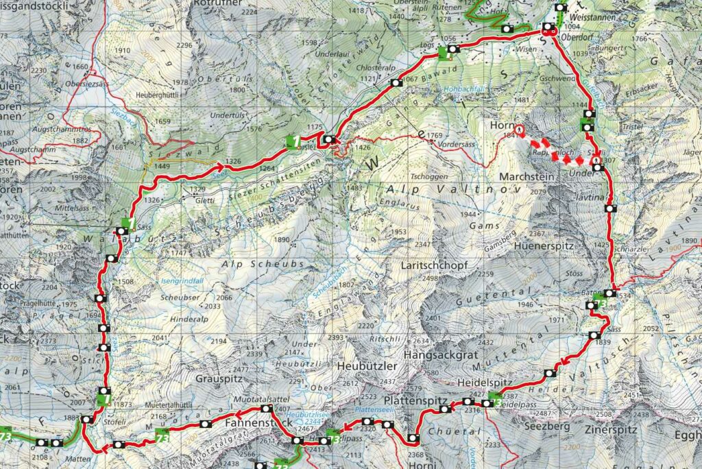
The route goes over the more classic route from Weisstannen to Batöni waterfalls (section 1), crosses the Indiana-Jones-Bridge, and climbs up towards Heidelpass (section 2), where there is a left-fork to St. Martin im Calfeisental. My route goes to the right towards Sardonahütte SAC (section 3). From the Sardonahütte fork, the route goes up Heubützlipass and on to Muotatalsattel (not to be confused with Muotatal, SZ) (section 4). From there, the route goes through the valley to Foospass-fork (section 5), and then all the way down towards Walabütz (section 6). From Walabütz to Weisstannen, there is an asphalt road and a parallel trail as well (section 7).
I went there in early June and there were a few (angled) snow fields to cross through the route. These look benign, but can be quite dangerous. Read up on the interwebs on how to cross them.
Section-1 is quite popular with tourists. So, expect the free parking spots at Weisstannen to get full on good days. It ends with the 3 waterfalls and the suspension bridge. The falls are pretty, but nothing special. The bridge itself is not scary enough to deserve the Indiana-Jones reference, but why not. I hear that the Indian Jones reference belongs either to Triftbrücke or Salbitbrücke – both of which are still on my bucket list. As I crossed the bridge towards section-2, I looked back to the other side of the bridge and saw the beautiful trail to Lavtinasattel snake its way up the mountain.
I thought to myself “next time baby”.
Section-2 from the bridge is breathtakingly beautiful and is where most of the elevation gain happens. I met a guy who told me that there was “Kein Chance” that I could do the full route. He said there was way too much snow up in the mountain valleys. I decided to check it out for myself, with the idea of turning back if things got sketchy. Later up in the mountains on section-2, I had to think hard about how much sketchiness was too much while I crossed/scrambled-across an angled snowfield towards the summit of Heidelpass. There were deep steps in the snow left by other hikers/runners and the snow-field angle itself was not steep. So, all ok.
Section 3 on the other side of Heidelpass is classic Swiss mountain-country with small lakes (Plattenseeli was a highlight) and beautifully runnable trails. This was the second most enjoyable part of the run. I knew that I could bail towards Sardonahütte SAC if things got sketchy in my route. Things did get sketchy, and I did not bail. Yikes.
Section 4 between the two passees (Heubützlipass and Muotatalsattel) overlooking the pretty Heubützlisee – that was the trickiest part of the day – with a large angled snowfield in early June (sigh). For some unknown and crazy reason, I didn’t use my running crampons and decided that my Inov8-Mudtalon-Speed running shoes with their crazy long lugs were enough to cross them. Bad mistake. I slipped and slid down the snowfield for 20 meters or so before coming to a halt. Here’s the deal: before venturing into the snowfield, I had assessed that even if I did slip and slide, there was no danger – as there was no abyss or rocky valley at the end. So, it was as safe as it could be. But that experience was a reminder that things can go wrong in the mountains. Preparing for the worst case is a good thing, and the worst case being “not-so-bad” is even more important. I picked myself up, and scrambled back to the trail. During the rest of section-4, I avoided the snowfield and went up and down the rocks around snow. It was not bad as it sounds. Crossing a small ridge at Muotatalsattel, I got down to the section-5 valley.
And this section-5 valley is gorgeous. And very runnable. I was kept company by Marmot whistles all the way down, crossing dozens of stream crossings with a steady downhill trail. At the Foospass-fork, there is a “only-in-Switzerland” box, stocked with beer, cola, juice, and a few other things – with a cash box. I had the cash, and I got my beer. Spoke for a bit with a guy who was camping the night there – who was himself well prepared – with an Aeropress and a Commandante coffee grinder in his backpack. I have a long way to go.
Section-6 was runnable as well, with a steady loud steam running next to you. Section-7 is back in civilization, as you make your way around a restaurant, a few parked cars here and there, many cows, and a lot of mud on the trails – all the way back to Weisstannen.
Total Garmin distance: 27km. Elevation Gain: 1905 meters. Total time: 6h:45m.
PS: Though I slipped on the snow-field, the Inov8-Mudtalon-Speeds were quite spectacular for the entire run. They dried very quickly (I crossed streams without blinking about getting wet), handled mud like they were built for it (duh), and were very grippy on downhills. If I can find a second pair, I will hoard it.